New GBA Technology Brief: Improve Your Drone Strategy
GBA Business Technology Committee
Drones offer geoprofessionals a means to enhance their reconnaissance or basemap quality. While free aerial photos are widely accessible online, there are instances where a higher resolution or improved shadows are necessary for specific presentations or gaining a different perspective of a site. Drones provide a cost-effective solution for achieving these requirements. They not only capture aerial photography of customized areas and viewpoints but also offer thermal imaging and laser mapping capabilities, revealing details otherwise concealed, even from a bird’s eye view. However, understanding key tips can give you a strategic edge when acquiring such imagery.
In the context of working on an eroding bluff, the accompanying photos illustrate a geologist mapping geological units to aid engineers in repair selection and assist contractors in bidding for the installation of anchor systems. Detailed oblique aerial photos describing the geological terrain prove valuable for contractors in comprehending the work area’s limitations. In this specific scenario, the geologist redirected city crews engaged in thermal drone imagery for analyzing the unhoused population to also collect oblique photography of the eroding bluff from multiple angles.
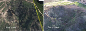
A comparison between public domain imagery and drone imagery underscores the advantages of the geologist’s choice of drone imagery as the optimal representation of the erosional feature. Drones also give the geologist the flexibility to choose lighting direction, altitude, and pitch for the photos. Therefore, consider the optimal time of day for desired shadows, maintaining a consistent altitude, ensuring photo overlap, and consider the benefits of thermal or laser capabilities when selecting drones. Cloud-based applications provide additional processing options, enhancing the overall efficiency of data utilization.
GBA’s Business Technology Committee is dedicated to disseminating the technology of the geoprofessional industry. Learn about GBA committees and how to join one HERE.